When earthquakes hit, they often come with little warning. Each year, about 500,000 earthquakes ripple through the Earth—some are felt, many aren’t, but all are part of a complex and dynamic system that geologists are trying to understand. Earthquakes are notoriously difficult to predict, but a new interdisciplinary effort is using AI to bring us closer. At Microsoft Research Asia, researchers have developed an AI-agent system designed to help geologists understand geologic maps—tools foundational to long-term earthquake assessment and risk analysis. Known as PEACE (opens in new tab) (empowering geologic map holistic understanding), the initiative introduces two tools: GeoMap-Bench (opens in new tab), a benchmark dataset for evaluating AI performance on geologic maps, and GeoMap-Agent (opens in new tab), an AI-powered agent to read and analyze them—work recently accepted at CVPR 2025.
Together, they represent a major step forward in bringing vision language models (VLMs) into the realm of earth sciences—and a promising way to speed up and scale geological insights that once took teams of experts days or even weeks to compile.
Why geologic maps matter
Geologic maps are essential tools in earthquake prediction, mineral exploration, infrastructure planning, and environmental assessment. They depict layers of Earth’s crust—faults, rock formations, and tectonic boundaries—often in intricate visual detail. When cross-referenced with tectonic activity and data on the crust’s stability, these maps help scientists assess seismic risk and understand long-term geologic trends.
But interpreting these maps isn’t simple. They’re dense with symbols, annotations, and embedded knowledge that even experienced geologists must study carefully. And while AI has made strides in image analysis and text comprehension, it still struggles to handle the complex, multimodal nature of geologic data.
In many ways, geologic maps are languages in themselves. They’re rich in meaning, but both technical and domain-specific understanding are needed to read them well.
GeoMap-Bench: Establishing a benchmark for geologic map understanding
AI applications in geology are still in their early stages. To close this gap, Microsoft researchers, in collaboration with the Chinese Academy of Geological Sciences and Wuhan University, created GeoMap-Bench—the first benchmark tailored for evaluating geologic maps. The team began by identifying five key capabilities for effective map interpretation:
- Extracting: Can the model retrieve basic information, like title, scale, and, longitude and latitude coordinates?
- Grounding: Can it find specific components when prompted by names or intensions?
- Referring: Can it match names to their corresponding properties, such as identifying the rock name by its legend color?
- Reasoning: Can it perform high-level logical tasks that require connecting information across components or incorporating external knowledge?
- Analyzing: Can it comprehensively interpret a given topic on the map and provide detailed and meaningful insights from various perspectives?
Based on these competencies, the team created 25 evaluation tasks (Figure 1) and compiled a dataset of over 100 representative geologic maps—sourced from over 7,000 maps provided by the China Geological Survey and the United States Geological Survey. From this, they generated more than 3,000 standardized questions to rigorously test multimodal AI models.

“If AI models can achieve more accurate geologic map interpretation, they will have a profound impact on surveying, geographic information mapping, cartography, navigation and positioning services, and even autonomous driving,” said Zhipeng Gui, director at Wuhan University’s School of Remote Sensing and Information Engineering. “It could signal a shift in geographic exploration and innovation.”
GeoMap-Agent: Accelerating AI-driven geologic map analysis
Building GeoMap-Bench was the first step. Researchers then used the benchmark to evaluate leading vision language models (VLMs), revealing key limitations in how current AI models interpret geologic maps. Their analysis identified three major challenges:
- Resolution: Geologic maps often exceed 10,000×10,000 pixels and require zooming in to identify fine details.
- Specialized knowledge: The maps rely on technical symbols and domain-specific knowledge that these models lack.
- Diverse visual elements: They contain visual elements—such as the legend, colors, and symbols—requiring capabilities in detection, classification, segmentation, optical character recognition (OCR), and reasoning.
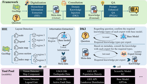
“Geologists urgently need digitalized geologic maps—a relatively straightforward technical goal,” said Yangyu Huang, senior RSDE at Microsoft Research Asia. “But our ambition goes further: we want AI technology to not only interpret these maps but also support practical applications, like assessing earthquake risks. Geologic maps can serve as a bridge, connecting various knowledge domains to enable more comprehensive insights.” To meet these challenges and realize this broader vision, the team developed GeoMap-Agent, the first AI assistant built specifically for geologic map analysis. It combines Microsoft Azure OpenAI technology with an architecture designed to handle complex maps. It advances existing models by efficiently handling high-resolution images and the complex relationships between map elements, and by integrating domain-specific knowledge.
GeoMap-Agent is structured around three main modules:
- Hierarchical information extraction (HIE): Breaks down high-resolution maps into manageable sections for detailed analysis, then integrates the results to form a comprehensive interpretation.
- Domain knowledge injection (DKI): Supplies the essential field knowledge for question answering, particularly for questions that require reasoning and analyzing.
- Prompt-enhanced question answering (PEOA): Crafts tailored prompts using both visual and textual inputs to generate better answers.
Evaluation and performance
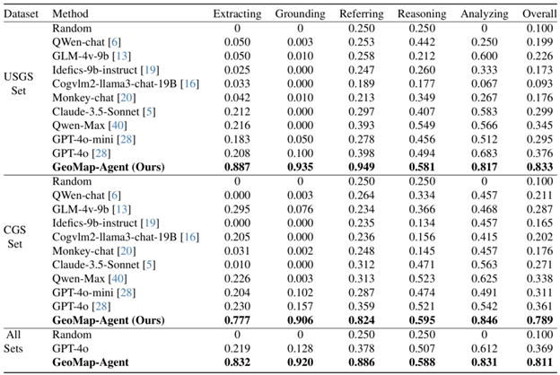
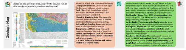
When tested against other AI models on GeoMap-Bench, GeoMap-Agent consistently outperformed other MLLMs (Table 1). In one case involving earthquake risk analysis (Figure 3), it pulled critical seismic data from maps, integrated expert knowledge, and identified high-risk regions—supporting faster, more informed decision-making.
Open-sourcing a new paradigm for AI in geology
Specialized maps—such as geologic, meteorological, and hydrological maps—serve as abstract representations of natural phenomena. By addressing core challenges in geologic map interpretation, GeoMap-Agent provides a scalable solution with potential applications across geosciences, Earth sciences, and urban planning.
However, AI-driven geology research requires interdisciplinary collaboration. Certain geological nuances remain difficult for AI to interpret without human expertise, making close cooperation among geologists, AI researchers, and data scientists essential to realizing AI’s full potential in geosciences.
“The research project GeoMap-Agent has the potential to significantly enhance the efficiency and accuracy of reading, analyzing, and interpreting geologic maps through automation,” said Yang Song, senior engineer at the Chinese Academy of Geological Sciences. “It can help geologists identify important geological features, such as layers and types of rock, and faults, while providing the data support needed for deeper analysis. For mineral exploration teams, the tool can streamline the extraction of information on mineral distribution and reduce manual errors. Engineers, meanwhile, may be able to more effectively assess geological risks—giving decision-makers a clearer understanding of geological conditions and helping ensure the safety of engineering projects. ”
Microsoft Research Asia is committed to advancing AI applications in geology and invites researchers worldwide to contribute to the continued development of GeoMap-Bench and GeoMap-Agent. By expanding the benchmark dataset and refining AI capabilities, we aim to establish a universal AI paradigm for specialized map interpretation.
Both GeoMap-Bench (opens in new tab) and GeoMap-Agent (opens in new tab) are open source, offering researchers a foundation for continued progress in geologic AI.